|
In Search of Badme Commission you said SIX (6) when you meant to say FOUR (4)!
Ethiopia’s campaign to reverse the April 13, 2003 Decision that affirmed Eritrea’s sovereignty over Badme has taken an unusual turn. The top leaders of the Ethiopian government are interpreting the wording of the April 13 Decision to state the opposite of what the Commission had said. The Commission’s interpretation of the relevant treaty places Badme inside Eritrea. It said so in its original Decision in 2002, and had repeated it several times since then. In its October 7 letter to the Security Council and in part in its response to Prime Minister Meles’ September 19 complaint, the Commission wrote:
In response to this Seyoum had this to say in his letter of October 16:
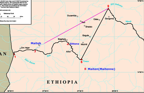
The Commission never said that “the boundary described in the 1902 Treaty leaves the Setit River at its junction with the Sittona.” What the Commission ruled was that the colonial boundary line goes from Point 6 (Setit-Tomsa) to Point 9 (Mareb-Mai Ambessa). What Meles and his Foreign Minister are saying now is that the Commission had ruled that the boundary runs from Point 4 (Setit-Sittona) to Point 9 (Mareb-Mai Ambessa). According to the Algiers Agreement the delimitation and demarcation of the border, by interpreting colonial treaties in accordance with applicable international law, is the exclusive authority of the independent and neutral Eritrea-Ethiopia Boundary Commission. Yet the Prime Minister and Foreign Minister of Ethiopia (both from Tigray, a region that is holding the rest of Ethiopia hostage to its territorial ambition) are trying to interpret the Commission’s Decision. This means they are taking upon themselves or usurping the authority of the Commission. Seyoum’s letter goes on to allege “The Commission has arrived at this conclusion [the colonial treaty boundary is Sittona to Mai Ambessa] with little ambiguity.” To the contrary, the Commission’s unambiguous conclusion was:
Misleading treaty interpretation Seyoum’s botched logic is as follows:
Seyoum is starting with an incomplete and flawed premise to prove Badme is in Ethiopia. The basis for the ruling on the Western Sector, according the Algiers Agreement, is both the 1902 treaty and applicable international law. Notice that it is not only the 1902 treaty or only applicable international law, but both. However, Ethiopia’s Foreign Minster reached his misleading interpretation by taking a part of the 1902 Treaty and ignoring applicable international law of interpreting Treaties. As will be shown later there was a reason why Seyoum had to surgically remove two of the three components of the Treaty from consideration. Note how he mutilated the Treaty of 1902:
But is that all what the Treaty said? Let’s look at the Treaty. Unlike the 1900 and 1908 treaties, the Treaty of 1902 is a tripartite treaty. It was a treaty signed by the British, the Ethiopians and the Italians. As a result the Treaty itself claims that it was “written in the Italian, English, and Amharic languages identically, all texts being official.” Here is Article I of the Treaty in English, Amharic, as well as the English translation of the Amharic version. English Version
The Amharic Version
The English Translation of the above Amharic text
As we can see the Treaty has three key specifications: 1) the border starting from Um Hajer is to run along the Setit until it comes to the confluence of the Setit and a certain named river; after this junction it is to be delimited so as to leave inside Eritrea (2) Mountain Ala Takura, and (3) the Cunama ethnic group. By concentrating on parts of (1) and leaving out (2) and (3), Seyoum gutted the heart of the Treaty. Contrary to what the treaty claimed for itself it was not written “identically” in the three languages. There are key discrepancies between the English/Italian and the Amharic versions. One significant difference is that the river written as Maieteb in the English/Italian versions is written as Maiten in the Amharic. There are two references to this river in the Treaty and in both cases the Amharic version uses the name Maiten. What makes this difference significant is the fact that there are two rivers that have names matching these two different names of the Treaty-river. One small creek named Maiteb at Point 3 almost matches the name in the English/Italian version. Another, a big river, named Maiten (known as Biya Tenne by the Cunama) at Point 8 matches the Amharic version. However, if the border was to be drawn from the junction of the first (Point 3) to Point 9 as Ethiopia argued before the Commission, then the border will leave more than 50% of the Cunama as well as Mt. Ala Takura in Ethiopia. This contradicts the Treaty’s specifications (2) and (3) enumerated above. On the other hand, if the border were to be drawn from Point 8 to Point 9, then Mt. Ala Takura and almost all Cunama would stay in Eritrea. We say almost all Cunama because there still is a pocket of Cunama settlement south of the Setit. A crucial observation here is also that the Treaty hasn’t given a delimitation of the border between the Setit and Mareb rivers, only its end points. According to the Treaty the border can only be delimited after determining where the eastern border of the Cunama is. One cannot interpret a segment of the Treaty in isolation to serve a specific purpose. The irony here is the name of the treaty river that Seyoum pegged his logic on was named and understood to be not his Maieteb but the Maiten by Seyoum’s predecessors. One question worth raising here is: was this difference in names an honest scribal error or otherwise? At the same time which was the language of the draft Treaty: the Amharic or one of the European languages? Since the treaty was negotiated with Menelik, a man who spoke neither English nor Italian, chances are that the draft was in Amharic. At the same time it can safely be assumed that the Ethiopian court had a better knowledge of the geography of the area and language than either the British or the Italians. Below is the Commission’s Decision Map 10. We have added a line (pink) that Ethiopia claimed and argued before the Commission is the correct colonial treaty border. We have also indicated the Sittona, a river that joins the Setit at Point 4. This is the river Ethiopia is now claiming is the correct Treaty border. The Maiten is seen joining the Setit at Point 8. As is evidenced from the correspondences between the chief Italian negotiator in Addis and the Italian governor in Asmara, the Italian knowledge of the rivers was shaky at best and mixed up at worst. It is also a matter of record that no Ethiopian regime before the Woyane ever thought the Treaty-river as Mai Teb. In fact, thirty years after signing the Treaty the Ethiopians were still referring to the Treaty-river as Maiten or Maitenne. For example Blatien Gieta Hiruy W/Selassie (Ethiopia’s Minister of Foreign Affairs 1930-1937) had written two crucial letters referring to the river as Mai Ten. Here is an excerpt from his letter of May 1931:
It is clear Eritrean (Italian) soldiers cannot enter into Adiabo by crossing the Mai Teb as Ethiopia tried to argue in its pleadings before the Commission. The Mai Teb is way out in the west near Um Hajer. That is why the Commission ruled it “is satisfied that the negotiators did not have in mind as the boundary the Ethiopian claim line running from Point 3 to Point 9.” (Para 5.84) Eight months later, in January 1932, Hiruy W/Selassie admitted not only the Treaty-river is the Maiten, but also the fact that the Eritrea-Ethiopia border according to the Treaty is close to the village of Adi Hagerai in Adiabo.
It is also interesting to find out that Ethiopian lawyers had produced the Hiruy letters in Amharic as evidence but they had intentionally airbrushed the Mai Ten in the original Amharic text and substituted it with Mai Teb to help them win their argument.
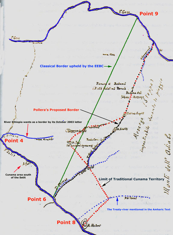
The case of the Treaty-river being as we saw it above, the other key specifications of the Treaty should also be examined. The first question to ask is where is the Mountain Ala Takura? The Commission didn’t provide the exact location of the mountain. No one who looks in modern maps can also locate a mountain by this very name as well. But using some key cartographic evidence, altitude and bearing, that are associated with Ala Takura indicate that Ala Tacura can only be Mt. Gomahalo, located east of the Point 6 – Point 9 line but west of the Mai Ten and way east of Ethiopia’s newly discovered love, the Sittona. Leaving Cunama in Eritrea: a ‘different order of significance’ As important as the differences in the names of the rivers and mountains are, the Commission clearly says that it doesn’t want to be drawn into the debate which is the correct river Mai Ten or Mai Teb or the Mountain. The reason? The Commission says that river junctions or mountains were not the object and purpose of the 1902 Treaty. The object and purpose of the Treaty was the placing of the Cunama inside Eritrea and the border is to be delimited or drawn so as it to leave not part of Cunama but the whole Cunama inside Eritrea. This specific delimitation requirement is the part Seyoum intentionally left out from his quote of the Treaty and a part he doesn’t want to talk about. In other words in the thinking of the ethnically-minded Tigrean Foreign Minister and his Tigrean Prime Minister, the Cunama are not people to worry about. This is in line with the mentality their ancestors had on the Cunama a century ago. It is to be remembered that in 1886, sixteen years before the Treaty of 1902 was signed, Ras Alula, a Tigrean Army general, had invaded Eritrea and ruthlessly massacred about two-thirds of the Cunama population (Haggai Erlich, "Ras Alula" pp.101-102). Erlich also reveals that “the fighters of the TPLF [notably Meles and Seyoum] were inspired by his [Alula's] heroism. ... For them he was the national hero. .. as well as the pride of Tigrean history.” The Cunama requirement of the Treaty is key to interpreting the Treaty and yet Seyoum doesn’t want to use it as part of his logic or argument against the Commission. That is why we said his logic is flawed or he had a false premise at the beginning. The inclusion of the Cunama in Eritrea was also the cardinal point the Commission used to interpret the Treaty of 1902. As the Commission states in Paragraphs 5.28-5.47 of its Decision, the reference to a mountain or river is of “little importance” compared with this requirement of the Treaty. But the “the second aspect, the requirement in paragraph (ii) that the line should be so delimited ‘that the Cunama tribe belong to Eritrea,’ is of a different order of significance.” The case of the Cunama might not be of significance to Ethiopia but to Eritrea and the Italians that negotiated the Treaty it was and still remains of utmost importance. Italy definitely didn’t want the Cunama to be part of Ethiopia, a country whose leaders were raiding them to get slaves. As far as the Italians were concerned their object from the very beginning was clear. They were in pursuit of a border that leaves the Cunama inside Eritrea. The parameter of negotiation given to Nerazzini, the Italian negotiator in Addis, by the Italian government as early as March 1897 was “to add the tribe of the Cunama to the Eritrean Colony.” This was five years before the Treaty of 1902 was consummated. Making sure that the Cunama stay inside Eritrea was also the objective of the Confidential Arrangement between Britain and Italy of 22 November 1901. That Agreement read in part:
This was also the understanding of Major Ciccodicola (the Italian representative who signed the 1902 Treaty on behalf of Italy) and Ferdinando Martini, the Governor of Eritrea. Ciccodicola wrote:
Even Degiyat Gherehelasse, the Ethiopian governor of Tigray at the time, recognized that the objective of the Treaty was the transfer of the whole Cunama land to Eritrea. Here is what he had written to Ciccodicola:
These background information make it clear why the Commission decided that delimiting the border so as the Cunama could stay inside Eritrea is of ‘a different order of significance’. This is also specifically why the Commission ruled that:
Where was the eastern border of the Cunama in c. 1902? If the border is to be delimited so that the Cunama would stay in Eritrea the question that needs to be asked is where was the Cunama border at the time the Treaty was signed in 1902? In 1887 Munzinger, had “described the eastern border of the Cunama by reference to the hills around the Godgodo Torrent (east of the Ethiopian claim line) but within the area embraced as Eritrea within the Eritrean line.” (Appendix B4) In addition Munzinger acknowledges that Tsada Medri, “composed of several villages”, represented “the western most inhabited point of Adiabo.” Tsada Medri is near Adi Hagerai. Near Adi Hagerai and Tsada Medri is also where the de Chaurand Map puts the eastern limit of the Cunama. This is Map 9 in the Decision. Leo Renisch (1881), in his book “Die Kunama-Sprache in Nordost-Afrika” had also stated that the “Kunama” people lived between 36º and 38º E and between 14º and 15º 30' N. Alberto Pollera, the Italian governor of the Gash-Setit, had also estimated the eastern border of the Cunama to be 37º 55'. (See map below.) Below is the Pollera map the Commission mentions in Paragraphs 5.51-5.54 of its April 2002 Decision. To make the map readable we have taken away its blue background as well as some other unnecessary details. In addition we have added the “classical” (Point 6 to Point 9) boundary line that has been upheld by the Commission. All these show that the easternmost border of the Cunama is east of what the Commission calls the “Classical line” and far to the east and to the south of Ethiopia’s new found border-river the Sittona. For example here are a few but prominent villages east of the Sittona that still carry Cunama names: Tomsa, Mochiti, Biyara, Shimbelina, Shiyaboni and of course the town and the plain of Baduma. Note: “biya” in Cunama means water. The name Takezze for the Setit is also a corruption of Tica, the Cunama name for the river. The current easternmost border of the Cunama north of the Setit is also nearly identical to this old border. Ethiopia’s ethnic federation itself recognizes the presence of the Cunama in Ethiopia. That is why there are two representatives in the Ethiopian Parliament, one in the House of the Federation and another in the House of Peoples’ Representatives. One of the representatives is for the special Kunama district around Sheraro. According to the specification of the 1902 Treaty no Cunama is supposed to remain inside Ethiopia. So why didn’t the Commission draw the border as far east as the true border of the Cunama? The Commission’s answer is “state practice.” What is that? The roots of this line is as detailed in the “Pro Memoria.” According to the “Pro Memoria” dated January 1904, Ciccodicola had discussed the delimitation of the border east of the Dukombia-Sittona road with Menelik some time between 1902 and 1903. In these meetings Emperor Menelik had requested that the border should not go south of the Setit. This meant the Cunama south of the Setit, particularly those in Aifori (See Pollera’s map above) should be left for Ethiopia, but those Cunama of the “upper part”, those north of the Setit and opposite Aifori will remain in Eritrea and “the baraca (the plain)” should be “divided in half between Eritrea and Ethiopia.” As the Commission noted correctly, “if the Ethiopian contention is correct, the ‘upper part’ of Aifori would, contrary to Menelik’s own request, have been part of Ethiopia” and didn’t have to plead for it." (Para 5.54) By the way it should be noted that the land of the Cunama opposite Aifori that Menelik admitted should stay inside Eritrea is farther east of Ethiopia’s newly found boundary- river the Sittona. It is Italian accommodation of Menelik’s request of dividing the plain, the Baduma plain, which gave birth to the Point 6 to Point 9 line around 1904. Since that time, until 1997, that line was accepted as the border between Eritrea and Ethiopia. It is to these 93-years of continuous practice of the states that the Commission, using the interpretation of applicable international law, ruled that the Point 6 (Setit-Tomsa) to Point 9 (Mareb-Mai Ambessa) border had crystallized as a border long before 1935 and the border of that time remains the border of today. It is this same classical Point 6 to Point 9 line was also the border Ethiopia was showing as it border to diplomats until January 26, 2001. The latter was the date Ethiopia formally stated its claim of the border. Meles and Seyoum’s misrepresentation of the Commission’s Decision To say “The Commission considers the river named ‘Meeteb’ in the Mai Daro map is really Sittona... The Commission therefore interprets the name "Maiteb" in the 1902 Treaty as being the present-day ‘Sittona’.” is one thing and to state, as they are now falsely alleging, “that the boundary described in the 1902 Treaty leaves the Setit River at its junction with the Sittona River” is quite different. In fact the Commission’s interpretation of the Meeteb of the Mai Daro as Sittona itself is very suspect. There is cartographic evidence from the time before and slightly after the signing of the Treaty that shows that some cartographers were aware of the existence of a river named Sittona as well as a river named Meeteb east of the Sittona. A close examination of the de Chaurand map’s Meeteb, particularly the reaches of its upper course relative to Adi Hagerai and Tsaeda Medri, shows that the Meeteb is indeed the Mai Ten not the Sittona. In any case the Commission was interested in the main object and purpose of the Treaty and that is why it followed its identification of the Meeteb with the Sittona immediately with the following comment:
In other words, according to applicable international law, the interpretation of treaties requires the use of the whole not parts of a treaty. The object and purpose of a treaty should also be taken into consideration. The important element of the 1902 Treaty, the object and purpose is precisely what Ethiopia tried to hide in its October 16 letter to the UN. In quoting the 1902 Treaty in the October 16 letter, the Foreign Minister of Ethiopia had butchered out the object and purpose of the treaty. Seyoum purposely and intentionally left out the part of the treaty that the Commission says is a necessary and important element for the interpretation of the relevant Treaty. Why is Ethiopia, after arguing before the Commission that the Treaty border is Point 3 (Maiteb) to Point 9 (Mai Ambessa), now arguing for the Sittona-Mai Ambessa line? The truth is that this is a Tigrean way of getting legitimacy for its illegal map, the map of Tigray, from 1997. The latest fight with the Commission is because it has refused to allow them cloak their aggressor’s map with the authenticity of its April 2002 Decision. The genuine path to lasting peace The aim of Ethiopia’s latest talk of “the Commission had misinterpreted its own Decision” is clear. It is an attempt to reargue a legal case it had already lost. Starting May 13, 2002 it had repeatedly tried, directly and indirectly, to reargue its case before the Commission. But the Commission’s stand from the beginning, June 24, 2002, was that there is no “possibility of appeal against a decision or the reopening of matters clearly settled by a decision.” Failing to convince the Commissioners to legally open the case, Meles and Seyoum are now trying to force revision of the Commission’s Decision to ensure Badme is awarded to Ethiopia, through intimidation of the EEBC’s staff and UNMEE, and continuing intransigence from implementing the Algiers Peace Agreement. Ethiopia’s assertion that the aim of the Algiers Agreement was to bring a lasting peace is correct. The difference is in how to achieve it. According to the Algiers Agreement the first and vital step towards a lasting peace is the acceptance as “final and binding” and the expeditious implementation of the delimitation and demarcation Decision of the neutral Eritrea-Ethiopia Boundary Commission. For sure it is not demarcation in itself but the willingness to abide by and to earnestly make it the tool of ending the conflict that brings a lasting peace. |