 |
 |
Ethiopias claim to Badme had been Rejected Unambiguously
Ghidewon Abay Asmerom March 13, 2003
This is the latest Ethiopian wail that
it should get Badme. This time it is Tekeda Alemu speaking. Two
weeks ago it was the Prime Minister who told the same news agency
that he found it difficult to see how the border town of Badme
could be awarded to Eritrea. Tekeda's statement is particularly
absurd. He is alleging the Commissioners who found Badme to be in
Eritrea are out of their "right mind". Well does that include the
two Ethiopia handpicked? What about the President of the Commission,
which Ethiopia's nominees had an equal say in selecting? The logic
must go that the Minority Regime in Ethiopia is not in its right
mind to select people that are out of their right mind. It's not
nice to badmouth people you have put in the commission yourself. These statements together with the Reports
of the President of the neutral Boundary Commission and the UN Secretary
General of March 6, 2003 make it clear that the Tigrean rulers of
Ethiopia are ready to go to yet another war to get land that is
not legally theirs. Which Line is "This Line"
? These statements by Ethiopian officials
also make it clear that the line in the Ethiopian statement Ethiopia
has understood that this line would be subject to refinement during
the demarcation process when the effective administration of the
Parties could be determined in the field, quoted by Sir Elihu
Lauterpacht is his 8th report to the UN is a reference to the famous
diagonal line that runs between the Setit-and Mareb Rivers. This
is also the line that runs through the heartland of a fertile land
that became a source of war in 1998. The April 13 Decision had said
that this diagonal line had long crystallized as an international
border and was binding on the Parties more than seven decades
ago. But what is at stake is not the Straight-line border, but which
side of the border the straight line leaves the village of Badme. What Ethiopias officials repeatedly telling the World is an admission that Badme is not on their side of the border. It would be hard to imagine they would be demanding for the refinement of the line come demarcation if the now famous village were on their side of the border. But anyone who has read the Decision carefully knows that the Commission has long rejected Ethiopias claim to Badme the village and the areas adjacent to it. This rejection is not hidden. It is out there in the Decision for anyone who cares to read. It is so easy to find that it doesn't even require a "magic eye" stare like the stereogram text below in Figure 1. If you can't see the hidden text below, don't spend your time staring at it. Finish reading and you will find what is in it.
We know the Apartheid Regime in Ethiopia
had lied to the people of Ethiopia the morning of the Decision.
All these "it is difficult to believe" statements are now their
way of admitting they have lied to their people and to the world.
Many in the past had already pointed the key paragraphs that make
it clear that Badme was not and is not legally part of Ethiopia,
here is again a brief summary of what the Commission had to say
vis-à-vis this point in those paragraphs. A Claim Line that Folded Under all
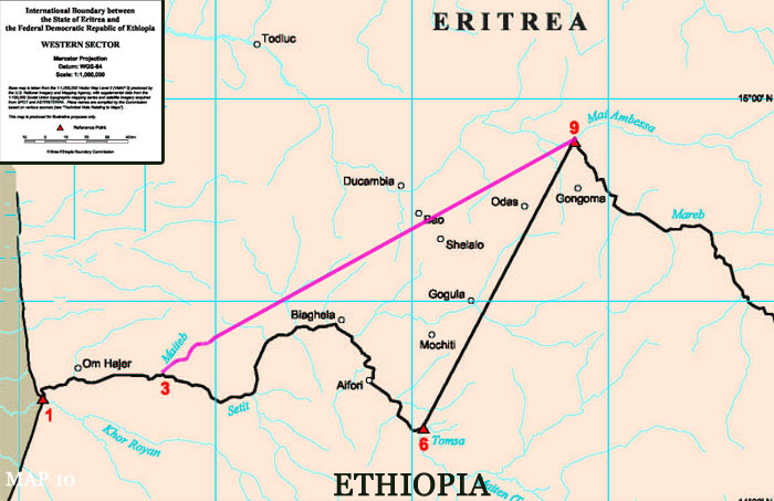
Legal Tests Though Ethiopia, through its claim line in the western sector, had claimed an area covering about a third of Eritreas Gash-Setit province, it had nothing to show for it in terms of evidence. Exploiting the early confusion between the Amharic and Italian/English texts of the treaty on a key river (the Amharic had Mai Teni and the Italian/English texts had Maieteb) Ethiopia argued that the 1902 treaty river was the tiny creek of Mai Teb about 20 km east of Um Hajer instead of the River Mai Teni (Bia Tenne) which is some 120 km farther east of the Mai Teb. The Map below is the April 13 border with Ethiopia's claim line (in pink) superimposed.
Producing a couple of wrong maps drawn
by Italy and one of its own Ethiopia maintained that (1) there were
no clear enough maps of the border around 1902-03, and (2) the Italians
themselves were confused as to where the border between Eritrea
and Ethiopia was. As a result it argued that the intention of the
treaty of 1902 was not to put the border as far as Eritrea wants
it to be or as it was being drawn in the past 100 years including
those drawn by itself. Of course there were two more problems in
the text of the 1902 Treaty Ethiopia didnt know how to square with
its claim line. The main problem for Ethiopia was how to reconcile
the 1902 treatys specific requirement that the border shall
be delimited by Italian and Ethiopian delegates, so that the Cunama
tribe belong to Eritrea. Ethiopias claim line falls far short
of doing that. Ethiopias contention, albeit weak, was (1) The
land of the Kunama could only stretch as far east as the Italians
thought it did in 1902, and (2) The incorporation of the Kunama
into Eritrea was not the central objective and purpose of the 1902
treaty. Eritreas argument was clear. The intended river of the
Treaty is as the Amharic text had it: the River Mai Teni or as
the indigenous people call it "Bia Tenne". This river is near the
eastern border of the Kunama and it is to this same River that the
Ethiopian Minister of Foreign Affairs, Bilaten Getta Hiruy W/Silassie,
was referring in his diplomatic exchange with the Italians as late
as 2 May 1931.
At the same time the particular purpose
and central objective of the 1902 Treaty was not a river, a mountain
but to demarcate the border so as to ensure that all Kunama remain
in Eritrea.
Rejecting Ethiopias claim line, the
Commission agreed with Eritrea that the classical or traditional
straight line from the confluence of the Tomsa with the Setit to
the confluence of the Mai Ambessa with the Mareb (Point 6 to Point
9 in the Decision maps) is the colonial treaty border. This is how
the Commission put it:
What the Commission is saying above
is that: the 1902 treaty does not read as Ethiopia wants it to read.
At the same time those who negotiated the treaty didnt have in
mind Ethiopias claim line as a border. Furthermore, the eastern
border of the Kunama is near Eritreas claim line not Ethiopias
claim line. If the Commission was to take Ethiopia's claim line
the Kunama would not remain in Eritrea. Finally the Eritrean claim
line was accepted as a border by both Italy and Ethiopia before
the two countries went to war in 1935. Thus, the border remains
with its classical (straight-line) signature where Eritrea claims
it is. This is an unambiguous rejection to Ethiopias claim to where
the border was and should be. Said in different words, Ethiopias
claim line, the line from Point 3 to Point 9, had failed all the
critical tests the Commission put it to. As we saw above it failed
the treaty interpretation test. Ethiopia's "Mai Teb" is not the
same as the Treaty's Mai Teni, at the same time Ethiopia's claim
line violates the key provision of delimiting the border "so
that the Cunama tribe belong to Eritrea." Ethiopia's claim line
also failed three more tests that came under the Commissions interpretation
of applicable international law. These are tests that relate to
the rules relating to the effect of conduct of the parties. According
to the Commission "the conduct of the Parties falls into three
broad categories:
This means not only did Ethiopias claim
fail the treaty interpretation test, but it also failed in all the
three categories specified above. Here is how the Commission summarizes
the failure of Ethiopias claim line to square with the evidence
that exists in the thousands of maps and how Ethiopia never protested
for decades the drawing of the border along that of Eritreas claim
line:
The Commission also found Ethiopias
evidence of activity on the ground tending to show the exercise
of sovereign authority by the Party engaging in that activity (effectivités)
vis-à-vis Ethiopias claim line not to be sufficiently clear or
substantial in scope and time as to make it displace, vary, or refine
Eritreas claim line. In the Commissions words:
In short, the Commission by rejecting
Ethiopias bogus claim line on one hand and affirming Eritreas
claim line on the other, had rejected Ethiopias claim to all areas
west of the classical Tomsa-Mai Ambessa line. This includes but
is not limited to Ethiopian claim to villages of Adi Teklai, Adi
Tseser, Badme, Dembe Mengul, Dichinama, Mochiti, Sembel, Shelalo,
and Sheshebit...etc. Thus it is in spite of the clarity of the Commissions ruling outlined above that the Tigrean Rulers of Ethiopia are now saying they find it difficult to see how the border town of Badme could be awarded to Eritrea, or absolutely difficult to believe that any person in his right mind would put Badme in Eritrea. It is not the right or not so right mind of the Commissioners that left Badme in Eritrea. It is the facts in the treaty and applicable international law that did it. If it was only a matter of finding it difficult to understand, we are certain the Commission could have helped Ethiopia understand the April 13 Decision. However, what is proving difficult is the fact that the Minority Regime in Ethiopia is telling the Boundary Commission you have decided that Badme would go to the country that administered the area at the time of the war and that means "you have to give it to us." Of course there is no single sentence in the Decision that even remotly implies that Badme will go to the country that administered the area at the time of the war. There is none. In fact as Ethiopia wanted it to be done the border was arbitrated as how it was before 1935. This is what we read in the Decision. The Commission has told Ethiopia unequivocally
and in unambiguous terms that the classical line will stand as a
border as it was throughout the years. Or in its own words:The
Commission does not find in them [in Ethiopias submission] evidence
of administration of the area sufficiently clear in location, substantial
in scope or extensive in time to displace the title of Eritrea that
had crystallized as of 1935. How much more clearly can the Decision
be than this? Now, from what the President of the Commission told the UN Security Council in the March 6, 2003 Report, Ethiopias understanding of the April 13 Decision, among other issues, is that the classical straight-line border between Tomsa and Mai Ambessa has to be "refined" during demarcation based on the subsequent practice of the Parties. But that evidence has already been ruled to be not sufficiently clear in location, or substantial in scope to make changes. Bringing this thing up is nothing short of trying to reopen the case. It is for this reason the Commission is characterizing Ethiopia's request as an attempt to "reopen" or "reargue" the final and binding Decision. It is also this request from Ethiopia that is undermining the whole peace process. The Border Commission has also made it clear that when it talked about "refinement" of the line in its April Decision what it had in mind was the part of the boundary line within rivers which both countries had "favoured the deferment to the demarcation stage." The Commission wanted to determine this line "by reference to the location of the main channel" that will be identified during the dry season. And of course the special nature of the delimitation of the border around Tserona, Zalambessa that was given by a semicircle had to be refined during demarcation. One other point of refinement is that the midpoint between the Eritrean and Ethiopian checkpoints at Bure is to be determined during demarcation. Other than these the "refinement" of the border talked by the Commission is to the seconds and minutes of coordinates not to the change of the shape of a line upon examining freshly submitted evidence as Ethiopia is saying. This is at the crux of the matter. The ball is now in the UN's court. It should not allow Ethiopia to reargue a case that it had already lost. Let an honest demarcation take place and it will confirm that "Badme is in Eritrea." |