Eritrea
 |
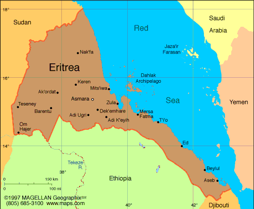
Geograph
Eritrea was formerly the northernmost province of Ethiopia and is about the size of Indiana. Much of the country is mountainous. Its narrow Red Sea coastal plain is one of the hottest and driest places in Africa. The cooler central highlands have fertile valleys that support agriculture. Eritrea is bordered by the Sudan on the north and west, the Red Sea on the north and east, and Ethiopia and Djibouti on the south.
Government
A transitional government committed to a democratic system.
History
Eritrea was part of the first Ethiopian kingdom of Aksum until its decline in the 8th century. It came under the control of the Ottoman Empire in the 16th century, and later of the Egyptians. The Italians captured the coastal areas in 1885, and the Treaty of Uccialli (May 2, 1889) gave Italy sovereignty over part of Eritrea. The Italians named their colony after the Roman name for the Red SeaMare Erythraeumand ruled it up until World War II. The British captured Eritrea in 1941 and later administered it as a UN Trust Territory until it became federated with Ethiopia on Sept. 15, 1952. It was made an Ethiopian province on Nov. 14, 1962. A civil war broke out against the Ethiopian government led by rebel groups who opposed the union and wanted independence for Eritrea. The bitter conflict raged on for 17 years against the hard-line Communist regime of the Ethiopian dictator Mengistu Haile Mariam until he was overthrown in May 1991.
The Eritrean People's Liberation Front (EPLF) took control of Eritrea and shared power in a multiparty government in Addis Ababa with the Ethiopian People's Revolutionary Democratic Front (EPRDF). They agreed to hold a referendum on Eritrean independence within two years and on April 2325, 1993, Eritrean voters almost unanimously opted for an independent republic. Ethiopia recognized Eritrea's sovereignty on May 3, 1993, and sought a new era of cooperation between the two countries.
While relations with Ethiopia remained good in 1995, those with the Sudan deteriorated. In Nov. 1996 Eritrea accused the Sudan of plotting to assassinate the president. The mission was thwarted by a Sudanese antigovernment group. Sudan denied the charge, although Eritrea provided specific names and dates of those allegedly involved.
Since Eritrea's independence, Eritrea and Ethiopia had disagreed about the exact demarcation of their borders, and in May 1998 border clashes broke out between them. After an eight-month lull that both sides used to reinforce their 600-mile common border, civil war broke out again in earnest. Both impoverished countries spent millions of dollars on warplanes and weapons, tens of thousands of soldiers have died, and refugees are legion.
A June 2000 cease-fire remains in effect, and a formal peace agreement was signed in Dec. 2000. The United Nations has provided several thousand troops to patrol the buffer zone between the two nations until a permanent border can be agreed upon.
 |
Area: 46,842 sq mi (121,320 sq km)
Population (2001 est.): 4,298,269 (of which 0.5 million are refugees awaiting repatriation) (average annual rate of natural increase: 3.0%); birth rate: 42.5/1000; infant mortality rate: 75.1/1000; density per sq mi: 92
Capital and largest city (1993): Asmara, 400,000
Other major cities: the ports of Massawa and Assab
Monetary unit: Nakfa
Languages: Afar, Bilen, Kunama, Nara, Arabic, Tobedawi, Saho, Tigre, Tigrinya
Ethnicity/race: ethnic Tigrinya 50%, Tigre and Kunama 40%, Afar 4%, Saho (Red Sea coast dwellers) 3%
Religions: Islam and Eritrean Orthodox Christianity
Literacy rate: 25%
Economic summary: GDP/PPP (1999 est.): $2.9 billion; per capita $750. Real growth rate: 3%. Inflation: 9% (1998 est). Unemployment: n.a. Arable land: 12%. Agriculture: sorghum, lentils, vegetables, corn, cotton, tobacco, coffee, sisal; livestock, goats; fish. Labor force: n.a.; agriculture, 80%; industry and commerce, 20%. Industries: food processing, beverages, clothing and textiles. Natural resources: gold, potash, zinc, copper, salt, possibly oil and natural gas, fish. Exports: $52.9 million (f.o.b., 1997): livestock, sorghum, textiles, food, small manufactures. Imports: $489.4 million (c.i.f., 1997): processed goods, machinery, petroleum products. Major trading partners: Ethiopia, Sudan, Italy, Saudi Arabia, U.S., Yemen, UAE, Germany.
Communications: Telephones: main lines in use: 23,578 (2000); mobile cellular: 0 (1995). Radio broadcast stations: AM 2, FM 1, shortwave 2 (2000). Radios: 345,000 (1997). Television broadcast stations: 1 (2000). Televisions: 1,000 (1997). Internet Service Providers (ISPs): 1 (1999).
Transportation: Railways: total: 317 km (1999). Highways: total: 4,010 km; paved: 874 km; unpaved: 3,136 km (1996 est.). Ports and harbors: Assab (Aseb), Massawa (Mits'iwa). Airports: 21 (1999 est.).
International disputes: dispute over alignment of boundary with Ethiopia led to armed conflict in 1998, which is still unresolved despite arbitration efforts.