The border dispute between Eritrea and Ethiopia has been continuing ever since Eritrea became independent and the present Ethiopian government came to power. Bilateral attempts to settle the dispute by jointly demarcating the common border had been in process, but these attempts were frustrated when Ethiopia unilaterally issued a new map that included large tracts of Eritrean territory and intensified its incursions into these areas to forcibly incorporate them into its domain.
The dispute escalated into armed conflict when unprovoked Ethiopian forces attacked an Eritrean patrol unit deep inside Eritrean territory on May 6, 1998. This attack was the latest in a long string of violations by Ethiopia of Eritrean territory and sovereignty, as well as the understanding between the two countries to maintain the status quo on the border pending a final agreement. In July 1997, Ethiopian troops (two battalion strong) occupied the Adi Murug area of Bada, in eastern Eritrea, dismantled the Eritrean administration there and installed a new Ethiopian administration. A few days later, Ethiopian authorities forcibly evicted Eritrean farmers from villages in the vicinity of Badme in southwestern Eritrea, saying that they had demarcated the area as Ethiopian territory. Eritrea protested to the Ethiopian government asking it to reverse those infringements, but the Ethiopian authorities who had created new facts on the ground refused to heed Eritrea's call. These incursions continued, resulting in Ethiopian occupation of large tracts of land, especially in southwestern Eritrea.
Eritrea had not been fixated on the issue of its border with Ethiopia. Firstly, Eritrea's border with Ethiopia is among the most clearly defined of colonial boundaries and Eritrea was confident that it can easily be demarcated through peaceful and legal means on the basis of the treaties that established it. Secondly, in light of the good relations that existed between the two neighbors and their avowed objective of promoting regional integration, the Eritrean government believed that the issue of borders was of secondary significance and should not thus be allowed to obstruct the development of bilateral and regional cooperation. Consequently, Eritrea consistently worked to resolve the tension arising from border issues quietly, peacefully, and in as much as was possible, bilaterally. It did not go public when Ethiopian troops occupied the Adi Murug area of Bada and forcibly evicted farmers from the Badme area, razing to the ground their dwellings and farms. It did not issue ultimatums or threaten all out war, as the Ethiopian government has now done. It simply called for the formation of a joint commission to resolve the issue on the basis of the treaties that established the border between the two countries during the colonial period. Eritrea's restraint, however, only encouraged the Ethiopian authorities, who might have misinterpreted it for weakness or lack of resolve, to push on with their flagrant violations of Eritrean sovereignty.
Yes. The border between the two states was delimited in treaties signed and ratified in 1900, 1902 and 1908 by the then Imperial Government of Ethiopia and the Italian colonial government in Eritrea. This border is, in fact, one of the most clearly defined in Africa, and it had functioned as the internationally recognized boundary between the two states during the colonial period and the Federation era. Even after Eritrea was annexed by Ethiopia in 1962, the former boundary served as the border for the provincial administration. Official Ethiopian maps under Emperor Haile Sellassie, and subsequently under the military government of Mengistu Haile-Mariam clearly illustrate this fact. Any map of Eritrea from Italian colonial times to the present, including all those that were produced by the State of Ethiopia and by the United Nations at the time of the Ethio-Eritrean Federation, confirm this internationally established boundary.
No legal alterations have ever been made. The first alarming sign of an intention on the part of Ethiopia to unilaterally and formally change the established border came in 1997 with the official publication of a map of the Tigray region of Ethiopia. Subsequently, Ethiopia embossed this new change in its new currency notes issued in November 1997 and simultaneously continued to unilaterally demarcate the border so as to coincide with its new illegal map. As any comparative view of this map with any of the earlier ones clearly demonstrate, this new map incorporates large swaths of Eritrean land into Ethiopia (see maps in Appendix). And even today, despite formal claims to respect international boundaries, Ethiopia has not officially rescinded this map.
Despite Eritrea's efforts to have the border demarcated through a joint border commission, Ethiopian's expansion into and expulsion of Eritreans from Eritrean territory intensified in a bid to occupy all the areas incorporated into the new Tigray map of 1997. When the May 6,1998 Ethiopian attack on an Eritrean patrol unit was repulsed and Eritrean forces drove the invading Ethiopian forces out of Eritrean lands they had encroached upon, the Ethiopian government issued an ultimatum on May 13, 1998 threatening that unless Eritrean troops unconditionally and unilaterally withdraw from the areas Ethiopia claims, it will attack and drive them out by force. This was a declaration of war, and indeed the Ethiopian army attacked Eritrea throughout the common border and bombed the Eritrean capital, Asmara. Thus, Ethiopia escalated its attack in the Badme area to a full blown war against Eritrea. Meanwhile, the Ethiopian government started the mass round-up, incarceration and expulsion of Eritreans and Ethiopians of Eritrean origin resident in Ethiopia. The Ethiopian media also started a frantic inflammatory campaign inciting hatred and confrontation against Eritrea and Eritreans.
In stark contrast to the Ethiopian approach, Eritrea has responsibly striven to defuse the situation and pave the way for a peaceful, lasting solution. It has called for the renunciation of the use of force. It has also proposed the demilitarization of the entire border, and the demarcation of the border by a third party on the basis of the internationally recognized treaties that established the boundary. The above points are incorporated in the following proposals forwarded by the Eritrean government:
The root cause of the conflict is the non recognition and violation by the present Ethiopian government of the border between Eritrea and Ethiopia established during the colonial period. Eritrea firmly believes that any dispute concerning the border can and should be resolved peacefully and legally and not by recourse to force. Eritrea thus welcomed and cooperated with the mediation efforts of various concerned parties from the outset. With all of them, Eritrea has always maintained that a lasting and just solution needs to be based on legal foundations and investigated facts, and not on political expediency. It is unfortunate that some good intentioned facilitators at the outset did not heed to this cardinal principle and their efforts led to closed doors, a fact exploited by the Ethiopian regime which is always bent on the use of force to usurp what it claims. The Organization of African Unity (O.A.U.) has finally came up with a proposal for a framework agreement for the peaceful resolution of the conflict. The Eritrean government has accepted this proposal as a basis for discussion, and has called for a cessation of hostilities while discussions on the proposal continue to diffuse the tension and create a conducive atmosphere for a peaceful process. This call is supported by the O.A.U. as well, but Ethiopia has rejected this call and is preparing to re-launch an-all-out offensive against Eritrea.
Both sides would have to agree to resolve the present crisis through peaceful and legal means, and reject solutions that are imposed by force. Both sides must accept to respect the established colonial boundaries between them and state so publicly. They must further agree that the actual demarcation of the border will be carried out on the basis of the treaties that established it by a mutually acceptable technical team within a clearly defined time-frame. It should be agreed that the demarcation be carried out in the presence of a third party to witness the process and to act as a guarantor of the outcome. Eritrea has publicly committed itself to these principles, while Ethiopia has not done so. Ethiopia continues to demand that Eritrea must unilaterally and unconditionally withdraw from areas Ethiopia claims and that Ethiopia administers these areas as a precondition. If not, it goes to war. Eritrea' s position has been for a quick demarcation of the border on the basis of the principles and measures stated above.
Since there are clear differences on the basis and genesis of the conflict, Eritrea believes that a full investigation of the existing border until the coming of the present Ethiopian regime to power and incidents around the border up to and including that of May 6, 1998 should be conducted by an independent commission. But this can be done in tandem with the demilitarization process and the demarcation of the border so as to definitively settle the dispute and end the conflict. It should not be used as an excuse to further escalate the current conflict and delay demarcation which is the ultimate solution.
Yes. This deplorable act can obviously harm the relations between the two peoples. It is important that the international community clearly condemns these criminal acts of 'ethnic cleansing' being perpetrated by the Ethiopian government. In a cynical bid to confuse the international community, Ethiopia claims that Eritrea too is expelling Ethiopian citizens from Eritrea. In fact, in resolutions it passed in June 1998, the Eritrean National Assembly has made it absolutely clear that it condemns such acts and has informed Ethiopians residing in Eritrea of their right to seek legal redress if they are subjected to any form of harassment or illegal act. Eritrea has further made it clear that any individual or organization is welcome to come to Eritrea to witness the status of Ethiopians living there. The facts of the matter are now openly acknowledged by specific United Nations agencies, representatives of the European Union and the International Committee of the Red Cross (ICRC). The O.A.U. has acknowledged that there is no "systematic or official action directed against Ethiopians in Eritrea." Unfortunately, the Ethiopian government has refused to heed the call of the international community to desist from these gross violations of human rights and international law. Anyone seeking independent confirmation of this can contact the United Nations and the Office of the High Commissioner for Human Rights.
Both countries have been expressing their readiness for a peaceful resolution of the conflict and have been appealing to the O.A.U., the U.N., other regional organizations and countries to help facilitate a peaceful resolution. The difference lies in the sincerity and commitment of their pronouncements and actions. Eritrea has been consistently and firmly articulating that there is no alternative to a peaceful solution to the conflict and has been reacting to peace proposals in good faith. The Ethiopian officials, however, have been engaged in double-talk. On the one hand, they say that they want a peaceful settlement of the conflict, and on the other hand they have been putting irrational preconditions, diverting from the main issue of the border dispute and beating war drums unless they have it their way.
Here are few examples of statements and pronouncements made by Ethiopian officials at different times:
The Ethiopian leader, Meles Zenawi, tells David Gough in Addis Ababa, "A nation's fate in war depends on its ability to mobilize resources. Eritrea's ability to mobilize will decrease as the crisis continues whereas ours will increase." The Guardian June 19, 1998Ethiopian Prime Minister Meles Zenawi said that [his government] "would teach Eritrea a lesson..."Reuters, June 23,1998
The Ethiopian Prime Minister, in an interview on Ethiopian television, asked about the deportations of Eritreans said that [the Ethiopian government] "has the unrestricted right to expel any foreigner from the country for any reason whatsoever. Any foreigner, whether Eritrean, Japanese, etc., lives in Ethiopia because of the goodwill of the government. If the Ethiopian government says 'Go, because we don't like the colour of your eyes,' they have to leave."The BBC, July 10, 1998
Almaz Meko, Speaker in Ethiopia's parliament, told reporters in South Africa, "Until now we have been preparing ourselves [to attack]. Now, we believe we have made enough preparations."Reuters, July 17, 1998
Negaso Gidada, President of the Federal Republic of Ethiopia said: "The use of force will come at the time when the government believes is right."The Ethiopian Herald, September 11, 1998
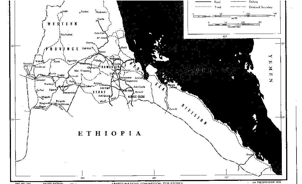
MAP 2
A Map of Eritrea produced in 1950 by the United nations Commission for Eritrea showing the administrative boundaries of the country. Here again, please note the straight-line border between Eritrea and Ethiopia.
MAP 3
This is the 1997 map of the Tigray Administration Zone of Ethiopia. The shaded or lined areas are Eritrean territory claimed by Ethiopia.