Date: Fri, 20 Sep 2013 14:24:23 +0200
Alaska and Ethiopia: Earthquakes in the Week of 12-18 September 2013
September 18, 2013 by <http://www.decodedscience.com/author/jennifer-young>
Jennifer Young
<http://www.decodedscience.com/alaska-ethiopia-earthquakes-week-12-18-septem
ber-2013/36958#respond> Leave a Comment
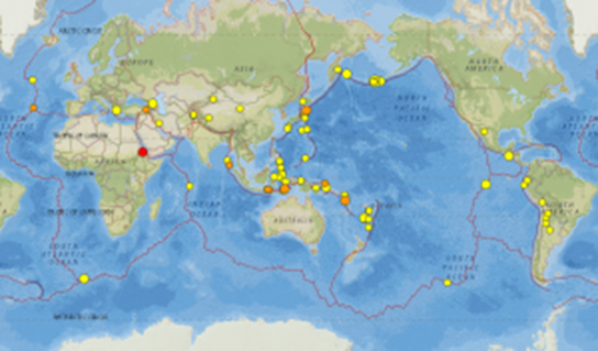
Earthquakes in the week of 12-18 September 2013. Image credit: USGS
Although the overall number of earthquakes recorded on the United States
Geological Survey's real time earthquake map for the week of 12-18
September isn't significantly different from the previous week, it was
nevertheless relatively quiet at the top end of the scale with just one
earthquake of at least magnitude 6 (?M6.0) and 18 of ?M5.0.
These larger tremors were scattered across the globe, with noteworthy events
on ocean ridges in the South Atlantic and eastern Pacific and tremors in
Greece and Georgia.
The Week's Largest Earthquake: M6.1 Alaska
At just M6.1, the largest earthquake of the week was nothing out of the
ordinary, particularly not for its location. Along with three more of the
ten largest tremors, this quake represents an aftershock from the
<http://www.decodedscience.com/m7-0-earthquake-strikes-alaskas-andreanof-isl
ands-30-august-2013/36022> M7.0 which struck on 30 August.
So far there have been around 60 aftershocks of at least M4.5 and over 300
of all magnitudes. The repercussions of major shocks such as this can be
expected to carry on for weeks or even months.
Continental Breakup: M5.0, Eritrea
Arguably the most interesting earthquake this week is the M5.0 which
occurred in Eritrea. Geologically, this area is fascinating: A rising plume
of rock sourced from deep within the earth is lifting the crust and will in
time initiate continental breakup of Africa, with a new ocean forming
between Ethiopia and Sudan.
The M5.0 of 18 September had its epicentre in Eritrea, north of the main hot
spot.
This region is known as a triple junction, with ocean ridges along the axes
of the Red Sea and Gulf of Aden already splitting Arabia from Africa and
creating new ocean crust. The third arm, the East African Rift, propagates
southwards to become the Great Rift Valley. With such dynamic processes in
action, it's unsurprising that this area is characterised by extensive
volcanism and accompanied by earth tremors, although large earthquakes in
the area are rare.
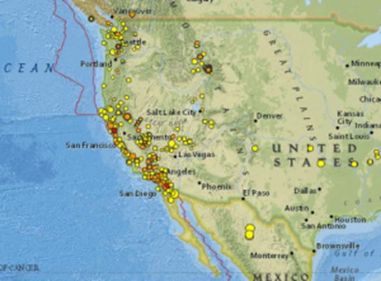
US Earthquakes: The Western States
The majority of significant earthquake activity in the States this week
continued to be in Alaska. Elsewhere there was no outstanding noteworthy
event, but this in itself offers an opportunity to look at the overall
pattern of tremors and to get some idea of the relationship between
earthquakes and topography.
The San Andreas fault zone, a major plate boundary, is clearly dominant but
other, older margins are equally important.
To understand the complex geological history of California, even at a very
simple level, we need to understand that the US west of the Rockies is made
up of various geological blocks which over time have 'docked' with
continental North America. The boundaries of these blocks are structurally
relatively weak - as is indicated by the broadly linear pattern of seismic
activity. It's also worth noting the scattering of tremors in and around
Montana-Idaho-Wyoming, which results primarily from volcanic activity
associated with the Yellowstone hot spot.
Creative Processes Cause Earthquakes
The Eritrean earthquake, and its association with the Afar mantle plume, is
exciting because it reminds us that earthquakes are not merely part of a
destructive process - even though most major tremors are associated with
subduction and melting of oceanic crust. The constructive processes by which
new crust is created also involve enormous crustal forces and, as a result,
are capable of generating noteworthy earthquakes.
<http://www.decodedscience.com/wp-content/uploads/2013/09/Digest-12-18-Septe
meber.png> Earthquakes in the week of 12-18 September 2013. Image credit:
USGS
Earthquakes in the week of 12-18 September 2013. Image credit: USGS
<http://www.decodedscience.com/wp-content/uploads/2013/09/466px-AFAR-MODIS.j
pg> Satellite view of the Afar Depression, site of a crustal triple
junction. The M5.0 earthquale occurred to teh north. Image credit: NASA
Satellite view of the Afar Depression, site of a crustal triple junction.
The M5.0 earthquake occurred to the north. Image credit: NASA
<http://www.decodedscience.com/wp-content/uploads/2013/09/seismicity-western
-n-america.png> Earthquakes in the western US show its geological structure.
Image credit: USGS
Earthquakes in the western US show its geological structure. Image credit:
USGS
(image/png attachment: image007.png)

(image/jpeg attachment: image008.jpg)
(image/png attachment: image009.png)